
Inland Communities and Neighboring Watersheds
Norwalk River Watershed AssociationInland Communities
Upriver from Norwalk, one first reaches the town of Wilton and then the town of Ridgefield. These two towns, combined with the city of Norwalk, contain more than 78 percent of the watershed. Their western neighbors, New Canaan and Lewisboro (NY), contain nearly 16 percent, entirely within the sub-watershed of the Norwalk River’s largest tributary, the Silvermine River. The towns to the east, Weston and Redding, contain just 6 percent of the watershed. This is shown in more detail here. A wealth of online information is available concerning the upriver communities of Wilton, Ridgefield, Lewisboro, and Redding. For the entire county of Fairfield CT, an excellent online resource is the blue pages.
Neighboring Watersheds
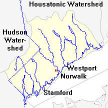
The Norwalk River watershed lies in an area that’s bounded by the Housatonic River watershed on the north and east, the Hudson River watershed on the west, and Long Island Sound on the south. Within this area (shown in here in yellow), the Norwalk is one of several rivers that flow SSE into the Sound.
Its neighbor to the east is the Saugatuck River, which arrives at the Sound in Westport. On the southwest its neighbor is the small Fivemile River (not shown on this map) and the Rippowam, which drains the area above the source of the Fivemile and brings its water down to Stamford. Above the Rippowam, the land west of the Norwalk River drains into the Hudson via the Titicus River (in the greyed-in part of the map).